
 A fantastic white frost glinting in the morning sunlight shining from a glorious blue sky greeted me as I rolled into the assembly field with a car full of kit, ready to set up the timing for the Walton Chasers. Tent up, generator running and computers on it was time for me to get a run, and Auto Download is now so reliable and easy to use, I can run with no worries that I am going to come back to sort out chaos, leaving others to deal with finishers.
Shoal hill is one of those little areas that is really starting to mature well. The mixture of mature forest, open heathland and now more and more reclaimed quarry land brings a surprisingly difficult orienteering experience with little pockets of more intricate contour detail and a fiendishly complicated network of paths. This all makes the area very difficult to map in combination with the new generations of dog walkers who come and go.
I had a good run, losing a little time on a couple of controls but it was my legs that started to give in towards the end of the 9km brown course, hips, feet and knees succumbing to the fast and furious pace on this very runable area.
As usual, it was close at the top for the local boys, with Iain Stamp pipping me by a minute but elite NOC runner Richard Robinson was 6 minutes clear, so I had to settle for 3rd.
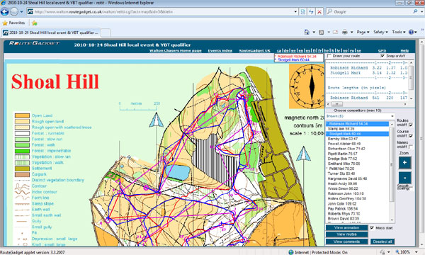
Rather than publishing my map here as usual I thought it an idea to remind non-orienteers, or those new to the sport, about routegadget. This fancy little webtool enables competitors to either plot their route manually or upload GPS tracks.
You can then watch little virtual races online, not only seeing where others have been but also enabling visually to see where you lost time.
Chasers routegadget is hosted by Paul Frost on the routegadget.co.uk site where he provides clubs the service for a very small fee to cover hosting costs http://www.routegadget.co.uk/
Check out the awesomeness of this area for MTBO sprint 😉
I was thinking the same like Em 🙂 Perfect place for sprint or even middle.
Hmmmm nice idea, good for a training event perhaps but its covered in bridleways, hence we have been in there on score events in the past…….
http://www.streetmap.co.uk/map.srf?x=397500&y=311500&z=120&sv=shoal+hill&st=3&tl=Map+of+Shoal+Hill,+Staffordshire+%5BHill/Mountain%5D&searchp=ids.srf&mapp=map.srf